Understanding the Indigenous History of the Land Now Called ‘Vancouver’
As we recognize National Indigenous History Month, it's crucial to reflect on the deep and enduring connections Indigenous peoples have to the land now known as Metro Vancouver. This piece aims to uncover some of the lesser-known histories of places we live, work and play and to highlight the valuable research, oral histories and resources that Indigenous communities and allies have stewarded and developed over time. We will explore the pre-colonial histories of various areas in the city, with a special emphasis on the traditional, ancestral and unceded territories of the xʷməθkʷəy̓əm (Musqueam), Sḵwx̱wú7mesh (Squamish) and səlilwətaɬ (Tsleil-Waututh) Nations around the Burrard Inlet and surrounding areas.
Although there are many who are committing their time and efforts to restoring Indigenous histories and the histories of the land we now call home, we acknowledge the lack of information and resources dedicated to this research. Only a few areas and Nations are covered in this blog, and it is by no means an extensive representation of the rich and vast histories of this land. We acknowledge the extent to which Indigenous people were displaced and the suffering that ensued and continues due to colonial harm. We hope to see more funding for research in this area for further understanding and appreciation of the need for reconciliation and redress. To learn more, please view our resources at the end of the blog.
A Glimpse into Indigenous Heritage Sites
- c̓əsnaʔəm: The City Before the City
- Sen̓áḵw: A Historic Coast Salish Village
- Stanley Park Established: A Site of Indigenous Displacement
- The Significance of xʔəl̓ílwətaʔł (Indian River Watershed) to Tsleil-Waututh Nation
Explore Additional Learning Materials
A Glimpse into Indigenous Heritage Sites
c̓əsnaʔəm: The City Before the City
One of the most significant Indigenous sites in Vancouver is c̓əsnaʔəm, an ancient village that offers a window into the life of the Musqueam people over 5,000 years ago. Located in what is now the Marpole neighborhood, c̓əsnaʔəm was a large and thriving community that played a crucial role in the Musqueam way of life. This site was known for its rich resources, particularly at the mouth of the Fraser River, which provided abundant food and materials.
Despite its historical significance, c̓əsnaʔəm has faced numerous challenges over the past 125 years. Archaeologists, collectors and even treasure hunters have disturbed the site, seeking artifacts and ancestral remains. The area has been renamed multiple times, including being called Great Fraser Midden and Marpole Midden, reflecting its colonial history. However, the Musqueam community continues to honour and protect this site, ensuring its legacy endures.
To learn more about c̓əsnaʔəm and its significance, visit the collaborative exhibition by the Musqueam First Nation, the Museum of Anthropology (MOA) at UBC, and the Museum of Vancouver (MOV): c̓əsnaʔəm – The City Before the City.
You can also watch the documentary exploring this ancient landscape and living culture: c̓əsnaʔəm – The City Before the City Documentary.
Sen̓áḵw: A Historic Coast Salish Village
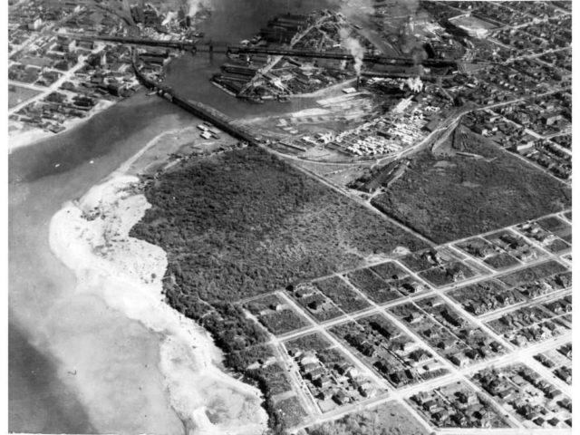
Aerial photo of Sen’ákw Indian Reserve No. 6
Sen̓áḵw, located in present-day Vanier Park, was a thriving village surrounded by the beauty and rich bounty of Musqueam, Squamish and Tsleil-waututh lands with people travelling by canoe throughout their great territories. This site was a centre of cultural and spiritual life until it was seized by colonial authorities. The village’s history is a testament to the deep-rooted presence of Indigenous communities in what is now Vancouver.
Learn about the history of this village from these resources:
- Sen̓áḵw - the story of the festival site:
Respect for the land prompted Bard on the Beach to create a resource with Lisa Wilcox of the Engagement Hub to rediscover some of the histories of this village. - History of the Sen̓áḵw lands:
Developed by the partnership between the Squamish Nation, Nch'ḵay̓ Development Corporation (the Squamish Nation's economic development arm) and Westbank — under the partnership name Nch'ḵay̓ West.
Stanley Park Established: A Site of Indigenous Displacement
“One morning in 1887, in a Squamish village immediately west of Vancouver called Chaythoos — today a sliver of Stanley Park — a family was eating breakfast when they were startled by the heavy thump of an axe hitting wood. And then another chop, and then another; the house shook. The family rushed outside to find a couple of men chopping at the corner of their home. Recounting the moment years later, August Jack Khatsahlano, a famous Squamish chief who was only a boy at the time, remembered his sister Louise asking them what they were doing. ‘We’re surveying the road,’ one responded. ‘Whose road?’ asked Louise. ‘Is it white man’s?’”
In 1887, the creation of Stanley Park – one of Vancouver's most famous landmarks – led to the removal of longtime Indigenous residents, disrupting their lives and communities. The Squamish village of Chaythoos was one such community affected by this development.
Many Indigenous homes were demolished to pave the way for infrastructure, but promised compensation never arrived. Subsequently, more Indigenous communities, including X̱wáýx̱way, were forcibly uprooted despite resistance. Ironically, amidst attempts to erase Indigenous heritage, totem poles were erected to represent cultural resilience.
Explore more about this story: An Untold History.
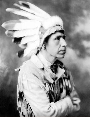
Squamish Chief August Jack Khahtsahlano, pictured here in 1932, grew up in what became Stanley Park before his family was forced to leave without compensation shortly before the park opened in 1888. SOURCE: City of Vancouver Archives, LP 3
Learn more about the Indigenous history of Stanley Park and support Indigenous businesses
- Download the Talaysay Tours App to learn from oral histories about the land, totems, art, culture and stories of Stanley Park, a gathering site and home to xʷməθkʷəy̓əm (Musqueam), Sḵwx̱wú7mesh (Squamish) and Səl̓ílwətaʔ/Selilwitulh (Tsleil-Waututh) peoples for thousands of years.
- Learn more about the History of Vancouver & Stanley Park through Indigenous eyes with Aboriginal Eco Tours.
- Or go on a talking trees tour in Stanley Park to learn how Indigenous people utilize the land for food, medicine and technology with Talasay Tours.
The Significance of xʔəl̓ílwətaʔł (Indian River Watershed) to Tsleil-Waututh Nation
The Tsleil-Waututh Nation traditionally lived according to a "seasonal round," moving between different locations throughout the year to make the best use of available resources. This practice underscores their deep understanding and respect for the natural world. This watershed is one of the only wild watersheds left in the Lower Mainland, and has significant cultural, spiritual and environmental importance to the Tsleil-Waututh people, embodying their deep connection to the land and water.
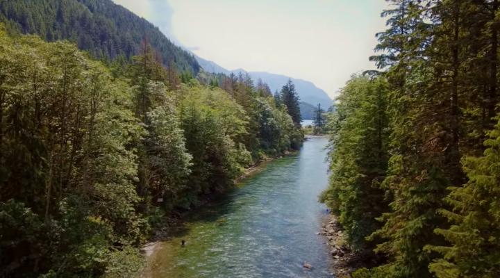
Watch a video featuring members of the Tsleil-Waututh Nation sharing what the Indian River Watershed means to them: The Significance of xʔəl̓ílwətaʔł.
Explore Additional Learning Materials
Interactive Tools, Historical Resources and Educational Kits
- Musqueam Place Names Map
Explore Musqueam place names, listen to audio recordings of their language, and view historical photographs.
Musqueam Place Names Map
- Musqueam Teaching Kit – Historic Timeline
Explore the history of the Musqueam Nation through this educational timeline provided by the Museum of Anthropology: Musqueam Teaching Kit
- Squamish Atlas Map
An interactive map showcasing places used, occupied, visited, or known by past and present Sḵwx̱wú7mesh language-speakers.
Squamish Atlas Map
- Squamish Lil'wat Cultural Centre
Offers a self-guided cultural journey through the histories and territories of the Squamish and Lil’wat Nations.
Plan Your visit
- Tsleil-Waututh Nation - Restoring a Healthy Inlet: An Interactive StoryMap Experience
Learn from Tsleil-Waututh Nation members about what it means to protect səlilwət (Burrard Inlet) and how reducing pollution from stormwater runoff is one major step towards that goal.
Visit the interactive StoryMap experience
- Tsleil-Waututh Nation - People of the Inlet
Learn about the origin, culture, and deep-rooted history of the Tsleil-Waututh Nation through this video.
Watch on YouTube
Additional Resources
- Metro Vancouver’s Indigenous Relations Work - First Nations in the Region Facts and Stats
Gain insights into the Indigenous population of Metro Vancouver with this informative document. Download the PDF
- Native Land Digital
An interactive map showing Indigenous territories, treaties, and languages globally.
Explore Native Land
- BC Assembly of First Nations Map
Interactive map showcasing First Nations territories in British Columbia.
View the Map
- Welcome to our Homelands
Produced by ISSofBC with funding support from Vancity Credit Union, this video features Indigenous individuals extending a welcoming message to newcomers to Canada. Watch on YouTube
